
Mapping is the science and art of preparing a map by determining the position of points and measuring the distances and angles between them. In other words, the collection of complications and their image on map surfaces is the main goal of its branch. The activity in this field of engineering can be divided into three main parts:
Ground operations: Taking points on the surface of the earth with one of the existing methods and using tools such as cameras. Mapping, GPS or GNSS mapping, UAV or classic outdoor mapping operations are known as the first step in map preparation. or correcting errors in data collection and preparation using relationships And the available software for drawing a map is a part of the mapping activity that is carried out in the office environment. The process is known. At this stage, the surveyor draws the map according to the existing rules and regulations.
Different methods of mapping
Chain mapping (triangle)
The sampled area is divided into a number of triangles.
The length of the sides is measured and the details of the interior angles of the triangles are recorded.
Then all the internal sides and angles are drawn on a drawing sheet in a suitable scale to prepare the map.
Route mapping (survey)
The whole plan design by a series of lines Lines that create angles with each other are enclosed. The length of the lines and angles are measured and drawn in detail on the drawing paper in a suitable scale to prepare the map. Conventional leveling
The elevation of various points on the ground is determined.
All elevation data required for construction activities are provided by this type of mapping.
triangulation
a grid of well-defined triangles in the segment The ground to be surveyed is formed.
One of the sides of the triangles is taken as the base line, then all other lines and angles are measured based on it.
< b> Two-way alignment
in leveling Rivers, ditches and other obstacles are used in this method to eliminate instrumental errors. so that the two sides meet at a point of the level surface.
The difference of the measured levels between two intersecting stations is determined through these measurements.
Photogrammetric mapping
Maps are prepared from photos taken from different stations by suitable cameras. The location of these cameras can even be inside an airplane.
The output of this method is a map of the location, or a 3D model of a real object.
Apart from the two main categories, we can Let's also classify different branches and disciplines that are directly related to this science as follows:
📐 topographic mapping
topographic projects with size Obtaining the physical characteristics of the earth concerned, these features include all natural and man-made features on Earth's surface. Topographic maps that show hills, rivers, cities, villages, forests, etc. are prepared using topographic mapping methods.
📐 civil mapping
engineering projects include the part that is used as part of preparation and planning for the estimation of new engineering projects including roads, railways, pipelines, Drainage etc. are done. Such as water supply and irrigation plans, mines, railways, bridges, transmission lines, buildings, etc., which are necessary in construction projects.
📐 Cadastral mapping< br>
Cadastre projects deal with the measurement, definition and registration of property boundaries. The cadastral map shows the boundaries of the properties and is prepared using mapping methods.
📐 hydrographic map Hydrographic projects are measurements that are made to determine the shape of the bottom of lakes, rivers, harbors and oceans and include the measurement of water flow in streams and estimation of water resources. Marine and hydrographic mapping is used to plan navigation routes and ports. Aerial uses measurements from a platform such as an aircraft or drone to produce a map of the ground, the control of such a map is obtained from ground surveys, but the details are obtained from aerial photographs. Preparation of this type of maps includes measurement and interpretation of aerial photographs.
Who is the surveyor?
The cartographer is responsible for measuring the effects and recording the data measured on, below and above the ground surface in different formats such as maps, images, spatial information tables, etc. Surveyors are actually the first and last engineers who work in a civil or construction project.
Calculations before creating any civil project, such as calculating the slope of the land, operation conditions, excavation, embankment and checking the location of the tolls. The surveying engineer does it, and the final control of each project in terms of the correct location of complications, the accuracy of operations, etc. is also with the surveying engineer.

Surveyor tasks
Determining the relative position of any object or point on the ground
Determining the distance and angle between different objects and positions.
Preparing a map or image to show an area on a horizontal plan.
Developing different methods through modern knowledge and technology and using them in measurements
Solving land-related issues such as excavation and embankment operations, etc. in optimal ways
< br>
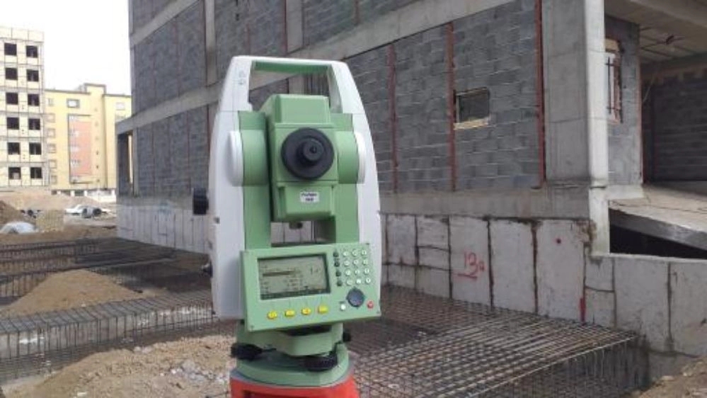
Introducing Mapping Tools
Special tools are needed to perform a correct mapping at the desired speed. Mapping equipment as a work tool of a surveyor depending on the purpose and accuracy of the project can cover a wide range from a simple tape meter to a smart multi-frequency receiver. Usually, the use of a special tool to perform All mapping activities are not possible and the surveyor works by using several different tools depending on the needs and goals of the project.